(a) Calculate the local mean time for John's location.
(b) What will be the local mean time at John's location if Mwamvua was living in Washington (960W)?
View Ans5. You have been invited in Zanzibar to assist in the exploration of a liquid energy mineral used for running automobiles, machines and engines:
(a) Identify that mineral.
View Ans(b) Outline two possible environmental problems caused by the extraction of the mineral named in (a).
View Ans(c) Suggest three ways to reduce the environmental problems caused by the extraction of the minerals named in (a).
View Ans6. Form Two students of Kioja Secondary School visited an industry which deals with spinning and weaving of cotton and wool.
(a) Identify the type of industry visited by the students.
View Ans(b)Describe three possible pollutants produced by the industry named in (a).
View Ans(c) Examine three factors for the location of the industry named in (a).
View Ans7. You were given a task to write a report on an economic activity of rearing livestock and poultry for food and commercial purposes;
(a) Briefly explain four challenges facing that economic activity in Tanzania.
View Ans(b) Describe four similarities in conducting that activity in Tanzania and Australia.
8. Study the sketch map of karagwe and then answer the questions that follows:
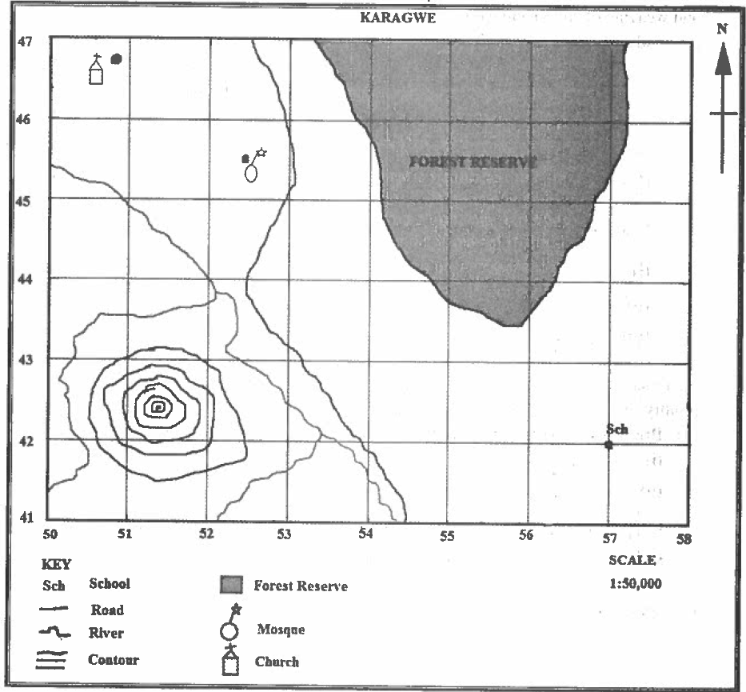 |
(a) By using grid reference, locate the position of the following features:
- A school
- A mosque
- A church
(b) Name four essentials of the map that have been used to draw that sketch map.
View Ans(c) Identify three methods which can be used to locate positions of features on that sketch map.
View Ans9. Read the weather data of Greenland and answer the questions that follow.
| MONTH | J | F | M | A | M | J | J | A | S | O | N | D |
| Temp(0C) | -18.9 | -17.2 | -10.6 | 0.5 | 10.5 | 16.7 | 19.4 | 16.1 | 10 | 1.7 | -8.9 | -15.6 |
| Rain(Mm) | 7.6 | 5 | 7.6 | 10.2 | 25.4 | 35.6 | 45.6 | 40.6 | 22.9 | 22.9 | 17.8 | 15.2 |
(a) Identify the type of the climate for the given area.
View Ans(b) Describe two characteristics of the type of the climate identified in (a).
View Ans(c) With examples, describe three possible activities which might take place in an area with the type of climate you mentioned in (a).
View AnsSECTION C (15 Marks)
Answer question ten (10).
10. The Earth has two kinds of movements which cause changes on the Earth's surface. Describe four effects for each type of those movements.
View Ans
Hub App
 For Call,Sms&WhatsApp: 255769929722 / 255754805256
For Call,Sms&WhatsApp: 255769929722 / 255754805256  MATOKEO KIDATO CHA IV 2023
FORM ONE SELECTION 2024
Matokeo Darasa VII 2023
SECONDARY REGIONAL EXAMS
PRIMARY REGIONAL EXAMS
FORM VI NECTA REVIEWS
FORM IV NECTA REVIEWS
FORM II NECTA REVIEWS
STD VII NECTA REVIEWS
STD IV NECTA REVIEWS
SECONDARY EXAMS SERIES
PRIMARY EXAMS SERIES
PRIMARY SUBJECT NOTES
SECONDARY SUBJECT NOTES
SECONDARY TOPICAL EXAMS
SECONDARY TOPICAL QUESTIONS
PRIMARY TOPICAL QUESTIONS
PRACTICAL EXAMS & NOTES
SECONDARY REGIONAL EXAMS
DOWNLOAD SUBJECT NOTES
SCHEMES OF WORK (PRIMARY & SECONDARY)
LESSON PLAN
SECONDARY LOG BOOKS
PRIMARY LOG BOOKS
LITERARY WORKS / UCHAMBUZI VITABU
METHALI ZOTE ZA KISWAHILI
Vitendawili Vya Kiswahili
FORM VI RESULTS 2023
FORM FIVE SELECTION 2023
Matokeo KIDATO CHA II 2022
Matokeo Darasa IV 2022
MATOKEO KIDATO CHA IV 2023
FORM ONE SELECTION 2024
Matokeo Darasa VII 2023
SECONDARY REGIONAL EXAMS
PRIMARY REGIONAL EXAMS
FORM VI NECTA REVIEWS
FORM IV NECTA REVIEWS
FORM II NECTA REVIEWS
STD VII NECTA REVIEWS
STD IV NECTA REVIEWS
SECONDARY EXAMS SERIES
PRIMARY EXAMS SERIES
PRIMARY SUBJECT NOTES
SECONDARY SUBJECT NOTES
SECONDARY TOPICAL EXAMS
SECONDARY TOPICAL QUESTIONS
PRIMARY TOPICAL QUESTIONS
PRACTICAL EXAMS & NOTES
SECONDARY REGIONAL EXAMS
DOWNLOAD SUBJECT NOTES
SCHEMES OF WORK (PRIMARY & SECONDARY)
LESSON PLAN
SECONDARY LOG BOOKS
PRIMARY LOG BOOKS
LITERARY WORKS / UCHAMBUZI VITABU
METHALI ZOTE ZA KISWAHILI
Vitendawili Vya Kiswahili
FORM VI RESULTS 2023
FORM FIVE SELECTION 2023
Matokeo KIDATO CHA II 2022
Matokeo Darasa IV 2022
WHATSAPP US NOW FOR ANY QUERY
App Ya Learning Hub Tanzania